Oil and Gas News | Oil and Gas Jobs | Oil and Gas Engineering
The Oil & Gas Hub
  • Main
  • News
  • Photo
  • Video
  • Oilfield Jobs
  • Learning Section
  • Oil & Gas Calculator

How to read contour lines on topographic maps

2017.12.24
3 169


In the oil and gas industry, before moving a drilling rig to location. It is important to study the lease area and pin point the right location to drill wells.

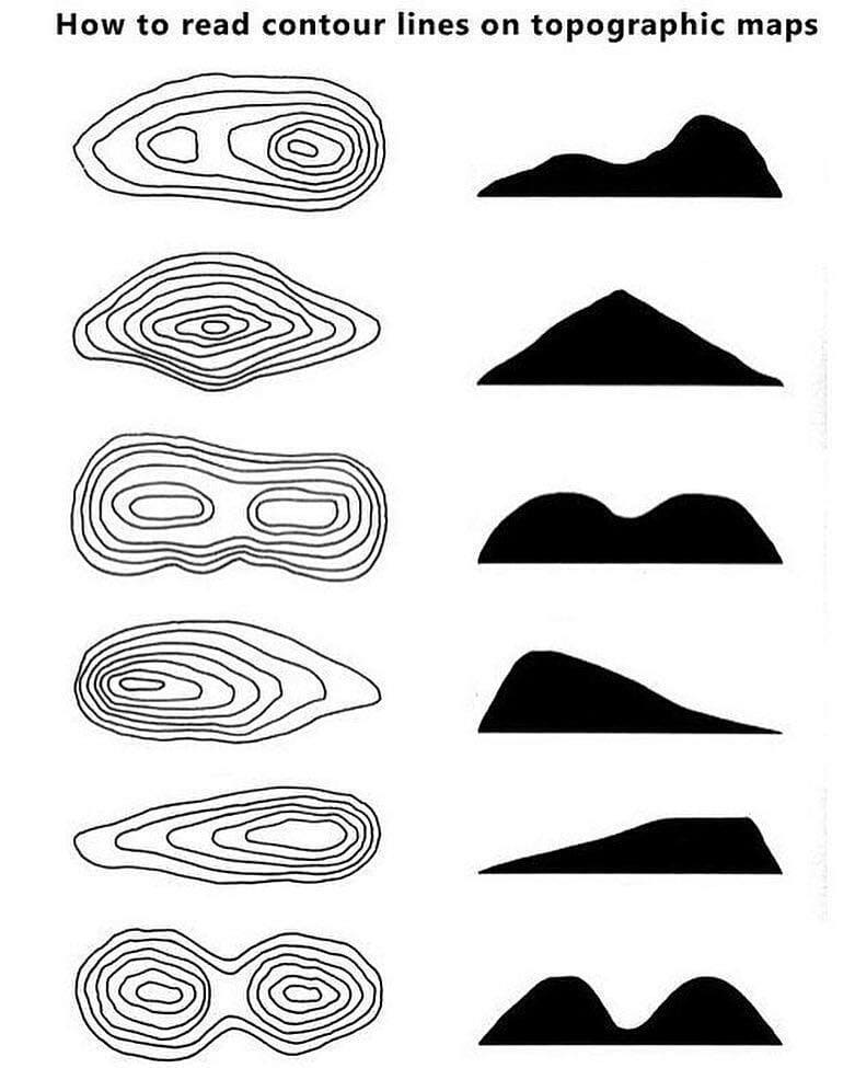
To achieve this, it may be necessary to read and interpret maps like the one in this post. The map (above) is a topographic map.

A topographic map can tell how deep the well can be before getting to the oil or gas reservoir. Again, through the Topographic map, it is possible to choose the easiest route to pass through when moving the rig to location especially on a land rig.

Related Posts

Essential STCW Courses for a Maritime Career in Offshore Oil and Gas
2025.07.23
40
Essential STCW Courses for a Maritime Career in Offshore Oil and Gas
Working in the offshore oil and gas sector often means operating in one of the most challenging envi…
Products Made From Crude Oil Other Uses For Crude
2025.06.26
105
Products Made From Crude Oil Other Uses For Crude
Crude oil is often thought of solely as the source of gasoline or diesel. However, this natural reso…
Understanding Offshore Drilling Jack-Up Rigs
2025.06.26
150
Understanding Offshore Drilling Jack-Up Rigs
Offshore drilling plays a critical role in the global energy industry, providing access to vast unde…
Downhole Tools Pocket Handbook: Run Procedures, Retrieval Steps, Calculations, Fishing Diagrams & Golden Rules
2025.06.24
233
Downhole Tools Pocket Handbook: Run Procedures, Retrieval Steps, Calculations, Fishing Diagrams & Golden Rules
The Downhole Tools Pocket Handbook is a compact, field-optimized guide created for drilling, complet…
Market quotes are powered by TradingView.com
© Oil and Gas News | Oil and Gas Jobs | Oil and Gas Engineering, 2025
ADVERTISE  | Contact Us  | Privacy Policy  
Made in studio Zuber